Developed by CHC Technology Co., Ltd(www.chcnav.com), LandStar 7 is the newest field-proven software solution for Android. Designed for high precision surveying and mapping tasks for your everyday work.
If you are new to LandStar 7, you will be impressed by its seamless work mode management, easy-to-use and easy-to-learn graphical user interface with simple operation. Extensive data import/export formats and multiple types of measurement and stakeout methods ensure instant productivity.
Top Features:
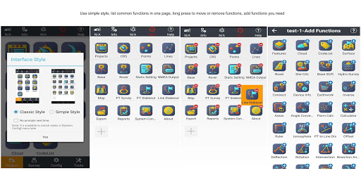
1.One-button Switching Dual Styles
Simple Style, for entry-level surveyors, with basic functions in one screen.
Classic Style, for professional surveyors, with all functions showing in different tables based on the frequently used work flow.
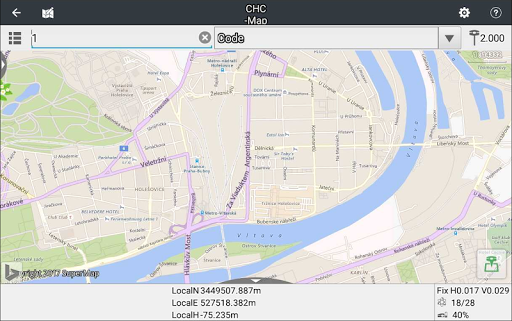
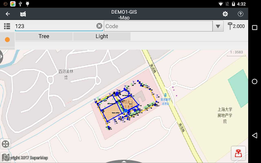
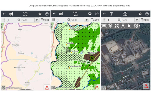
2.Various Base Map Displays
OSM, BING, Google, WMS online maps.
DXF, SHP, TIF, SIT, KML, KMZ offline maps
3.Extensive Import and Export Data Formats
Import from DXF, SHP, KML, KMZ, CSV, TXT and CGO formats.
Export to DXF, SHP, KML, KMZ, RAW, HTML, CSV, TXT formats.
Customized import and export contents in CSV or TXT formats.
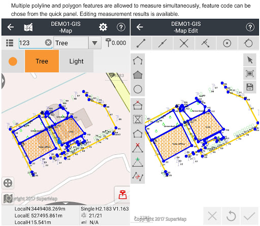
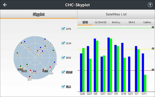
4.Various Types of Measurement
Supports static, RTK and stop & go measurement.
7 methods of point measurement, including topographic point, control point, quick point, continuous point, offset point, EBubble compensated point and corner point.
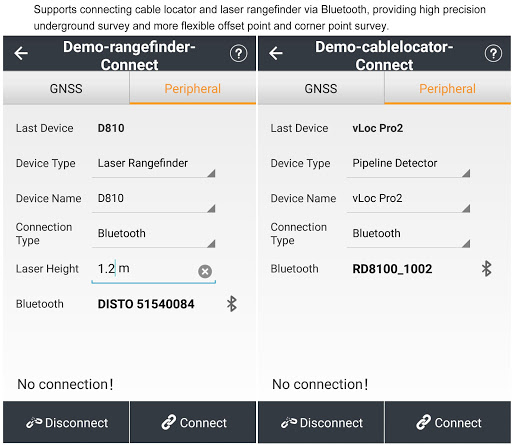
5.Various Peripherals Supported
Pipeline detector, VIVAX-METROTECH vLocPro2.
Laser rangefinder, Leica Disto,SNDWay and Bosch.
Echo sounder, sonarmite,NMEA DPT and DBT.
6.Convenient Work Mode Management
Presetting common work modes of base and rover, switching work modes by one button.
Convenient to work in stop&go based on real-time kinematic (RTK) mode and static mode can be set at the same time.
7.Standard CGD correction file
CHCNAV own CGD file for grid/geoid correction. Datum grid, plane grid and height geoid files are integrated in one CGD file, and each CGD file name is corresponding to coordinate system.
Multiple grid formats are available, GGF, BIN,GRT, GRD, GSF, GRI,BYN,ASC.
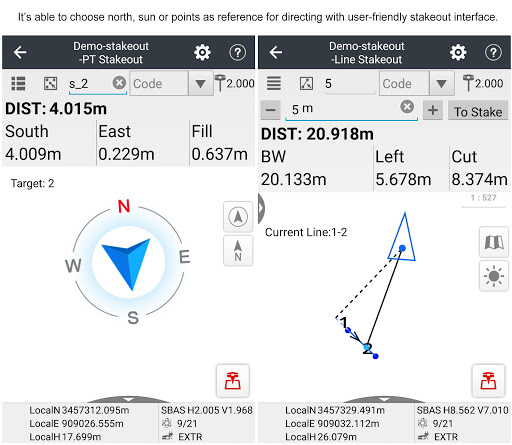
8.User-friendly Stakeout Interface
Two modes for stakeout, map mode shows the current position and target position, compass mode shows the target direction.
Users can set North, Sun or point as a reference direction.
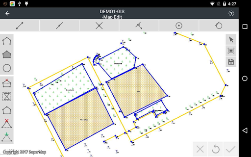
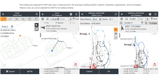
9.Multiple Types of Stakeout
Point and line stakeout by snapping feature point on DXF base map or survey point.
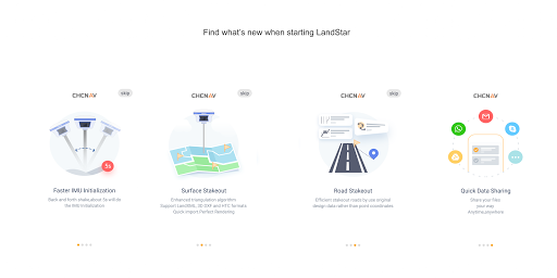
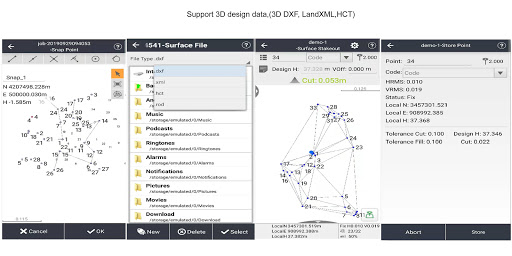
Surface stakeout with 3D DXF, XML, HCT formats.
10.Correction Repeater Function
Easily repeating correction data from RTK network or radio mode to other rovers via radio.
RTCM Transformation Message
Using RTCM transformation messages (1021-1027) for datum transformation, projection, automated grid position and geoid adjustments.
11.CHCNAV Cloud Service
Allows for uploading and downloading projects, coordinate systems, work modes and code lists.
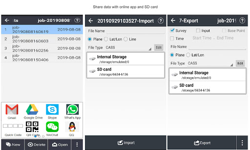
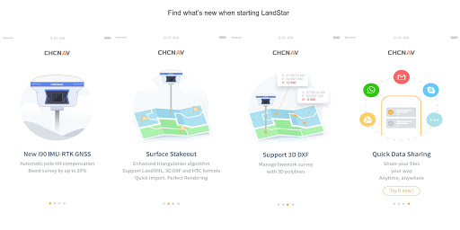
12.Quick Data Share
Use Gmail, WhatsApp, Google Drive, Skype to share your data
Share your projects, coordinate systems, points, work modes, codes, reports and results.
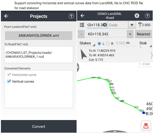
13.Powerful Road Functions
Create road elements in field, perfectly match your design data.
Support center line, cross section, profile, slope, structure, culvert and stakes.
Different views are available for stakes, slope, structure and data check.
14.Field Hardware Support
Supports CHC i90 with firmware v2.0.11, i80/i70/M6 receiver with the firmware v1.6.55, i50 receiver with the firmware v1.0.38, X91+/X900+ receiver with the firmware v8.39 and above, as well as internal GPS of Android smartphone and handheld controller.
15.Data Collection Hardware
LandStar 7 used with CHC HCE320 is the most compatible way, it can also be used with CHC HCE300, LT600, LT700, LT700H or other Android devices of v4.2 and above.
16.Language support
LandStar7 is available in Bulgarian, Croatian, English, Finnish, French, German, Greek, Hungarian, Iranian, Japanese, Kazakh, Korean, Persian, Polish, Portuguese, Russian, Simplified Chinese, Spanish, Slovak, Thailand, Traditional Chinese,Turkish,Mongolian and Vietnamese.
1.Add Dutch local coordinates,support GTX geoid file.
2.Support GDM export.
3.Support GNSS reciever i73.
4.Support dual-frequency depth sounder Hydrolite DFX.
5.Optimize the function of road stakeout.
6.Optimize SD card read & write.
7.Optimize the surface fitting method.
8.Fixed some other known bugs.
1.Support Android 10
2.Faster IMU initialization
3.Support updating firmware over the Internet
4.Add surfaces management
5.Support the configuration of Centesimal Angle
6.Support DBT or DPT protocol with depth finder
7.Added Mongolian and Vietnamese
8.Added cooridnate system of Saudi Arabia
9.Support base station position change reminder
10.Fixed some other known bugs
1.Support i90 IMU RTK
2.3D DXF stakeout
3.Surface stakeout with XML/3D DXF
4.Support LT700H
5.Share data via common app
6.See news when starting
7.Use keyboard shortcut
8.Integrate GNSSTool inside
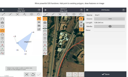
9.Add points into existing polygon
10.Draw features on image
11.Transfer data with SD card
12.New algorithm to better stakeout
13.Calculate area in hectare
14.Measure offset points with known data
15.Add points from DXF into stakeout library
16.Use new Russian XML file
17.Use CRS of USA and Canada
1. New simplified user-friendly interface display
2. Multi-polylines DXF stakeout
3. Alternative vertical alignments methods
4. New coordinate systems for South Africa and Brunei
5. Support LT700 Android tablet as the controller
6. Optimized compass guidance
7. Accelerate rending speed of DXF maps
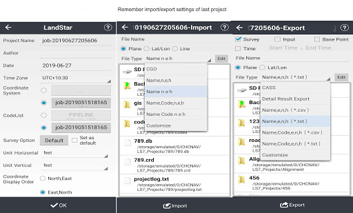
8. Remember import/export settings of the last project
9. Improve the successful connection rate of SNDWay and D510
10. Some other improvements
1. Fixed issues in the coordinate systems grid file
2. Fixed issue with multi-language in displaying abnormally
3. Fixed issue which HCE300 and HCE320 has different functions in traditional Chinese
4. Fixed issue when export .csv there is a strange word before point name in Korean
5. Modify coordinate system parameters in Morocco
Fix coordinate system can not be selected in Portuguese.
1.Allows one point to own multiple codes for sharing this point with different features
2.Allows for importing KMZ and KML file as a base map and exporting survey results as KMZ file
3.Available to use BYN geoid file for coordinates transformation now
4.Available to use oblique stereographic projection type now
5.Quick options of selected features
1.Support ViVAX vLocPro2 cable locator and Leica DISTO D810 touch rangefinder.
2.Support LandXML format for road stakeout.
3.Support logging static data when doing RTK measurement.
4.Stakeout interface has been optimized, it supports north, sun or point as direction reference.
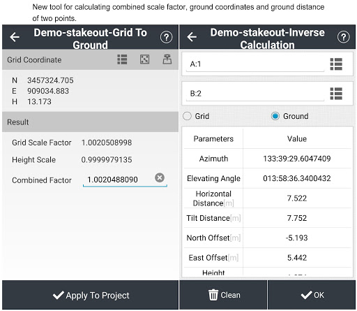
5.Be able to calculate combined scale factor, ground coordinates and ground distance of two points.
6.Support XML format for Russian cadastral surveying, GSB format datum grid for German, as well as GT format for Finland.

 Huawei Mate 9 Pro